|
|
HIERARCHIC STRUCTURAL LINEAMENT ANALYSIS |
The price and duration of Hierarchic Structural Lineament Analysis (HSLA) are determined by: (1) the area of the analysis, (2) by the resolution (synonyms: spatial resolution, ground resolution) of the satellite/aerial image in use, (3) by the scale at which the Client wants the analysis to be carried out.
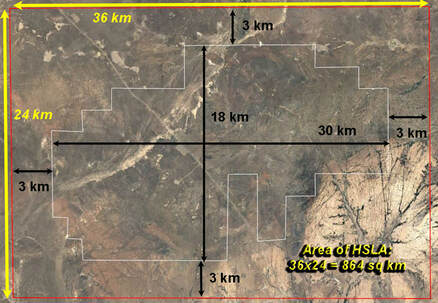
(1) AREA. To exclude distorting margin effects of the data during subsequent processing the area of the analysis must be larger than the direct area of the property under the study. In practice, we extend the dimensions along the main orientation axes by 10% as it is shown in the following picture (right).
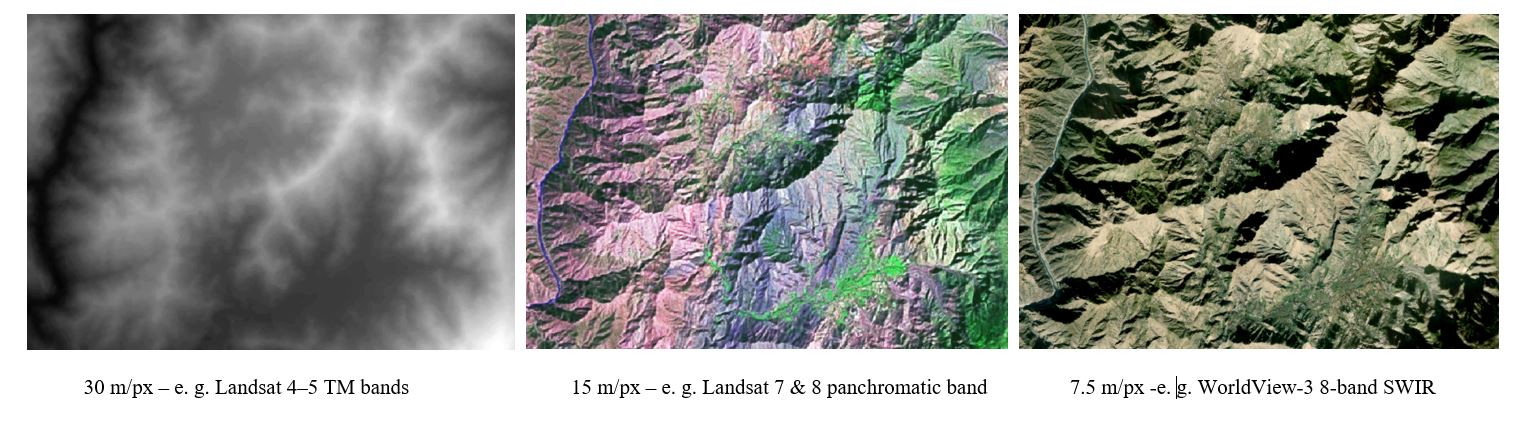
(2) RESOLUTION. Images of the same area reveal more structures with resolution increase - figure below. Simplifying, the doubling the resolution results in 4 times more identifiable linear structures. Provided that the extraction of the lineaments is carried out manually, it leads to increase of the HSLA duration (work load). Consequently, the cost (price) of analysis for the same area grows with the increase of the resolution.
(1) AREA. To exclude distorting margin effects of the data during subsequent processing the area of the analysis must be larger than the direct area of the property under the study. In practice, we extend the dimensions along the main orientation axes by 10% as it is shown in the following picture (right).
(2) RESOLUTION. Images of the same area reveal more structures with resolution increase - figure below. Simplifying, the doubling the resolution results in 4 times more identifiable linear structures. Provided that the extraction of the lineaments is carried out manually, it leads to increase of the HSLA duration (work load). Consequently, the cost (price) of analysis for the same area grows with the increase of the resolution.
(3) SCALE is another price/duration determining factor. The scale is somewhat similar to the resolution - more detail scale leads to about more work load. On the other hand, there is a commonsense correlation between the scale of the requested analysis and the necessary resolution to do this analysis.
To produce the lineaments map of 1 : 5 000 scale (1 cm =50 m) it would be pointless to use Landsat image with 30 m/px resolution - there would be mapped NO detectable structures with their dimension smaller than 30m (either width or length).
By the same token, for lineament mapping at 1 : 50 000 scale one does not usually use expensive images with 1 m spatial resolution; Landsat images with 15-30 m/px resolution may be quite satisfactory.
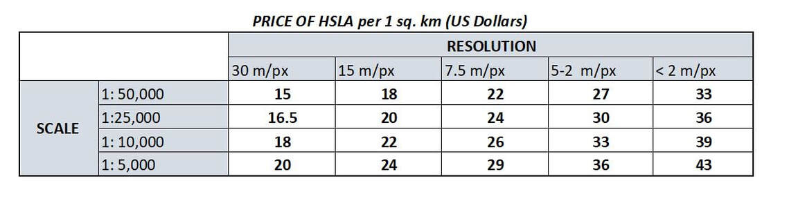
The concrete specifications of the planned HSLA are discussed with the Client on the case to case basis. The standard price list for the analysis per 1 sq. km is shown below (without applied discounts and/or special conditions).
To produce the lineaments map of 1 : 5 000 scale (1 cm =50 m) it would be pointless to use Landsat image with 30 m/px resolution - there would be mapped NO detectable structures with their dimension smaller than 30m (either width or length).
By the same token, for lineament mapping at 1 : 50 000 scale one does not usually use expensive images with 1 m spatial resolution; Landsat images with 15-30 m/px resolution may be quite satisfactory.
The concrete specifications of the planned HSLA are discussed with the Client on the case to case basis. The standard price list for the analysis per 1 sq. km is shown below (without applied discounts and/or special conditions).
DISCOUNTS: For projects costing $20,000 - 30,000 a 10% discount is given; $30,000 - 50,000 - 15%, >$50,000 - 20%.
EXAMPLES OF COST ESTIMATION
For the property with the area 864 sq. km mentioned at the beginning:
- the HSLA at 1 : 50 000 scale and using the satellite image with the resolution 30 m/px will cost 864 x 15 = 12,690 US dollars*.
Processing of the data with various algorithms (rose-diagrams plotting, contouring, building an ArcMap Project, compiling the Project Digital Delivery Package, exploration targeting and report compilation cost additional $1,500. The final cost of the project from the beginning to the end will be $14,190.
WORK DURATION - 3-4 weeks.
- the HSLA at 1 : 25 000 scale and using the satellite image with the resolution 7.5 m/px will cost 864 x 24 = 20,736 US dollars. Now, the 10% discount is given, so the actual price will be $18,662. *
Processing of the data with various algorithms (rose-diagrams plotting, contouring, building an ArcMap Project, compiling the Project Digital Delivery Package, exploration targeting and report compilation cost additional $1,500. The final cost of the project from the beginning to the end will be $20,462.
WORK DURATION - 4-5 weeks.
* If the project is done for Canadian Mining Companies the provincial taxes must be added.
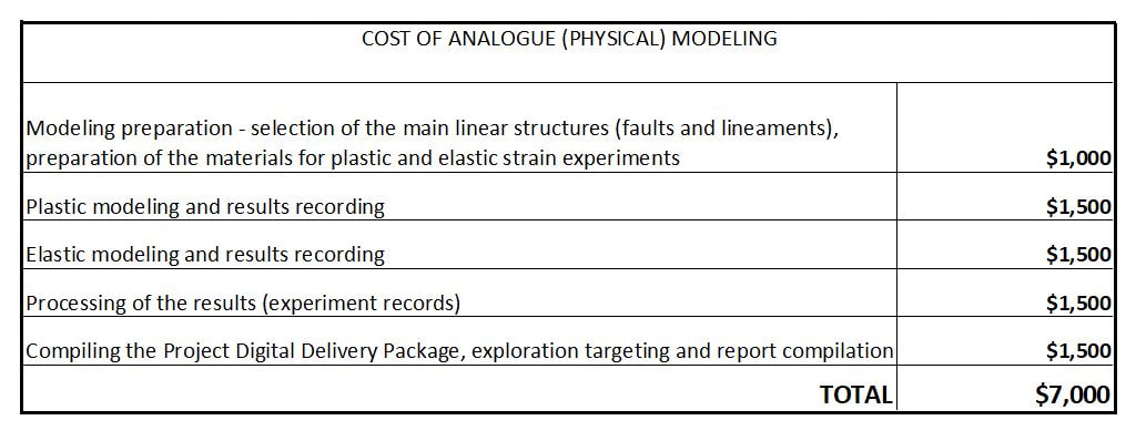
ANALOGUE (PHYSICAL) MODELING TO OUTLINE STRAIN/MINERALIZATION CONCENTRATORS
Analogue (physical) modeling can play a role as an independent method of exploration targeting, as well as be a part of the full Remote Exploration Method (REM).
Main benefit of the modeling is its low cost and speed - the application of the method takes about two weeks (12-14 days). Another advantage - independence from the scale/area of the region under the study.
The cost&duration of the method application to 2x2 km area, and to 100x100 km will be the same (see details in REMOTE EXPLORATION METHOD page). *
* If the project is done for Canadian Mining Companies the provincial taxes must be added.